
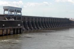
In 1930, the U.S. Corps of Engineers was directed to complete an engineering survey of the Tennessee River to determine the feasibility of establishing complete river navigability. The resulting report recommended a series of nine main river dams and several tributary dams to allow for a minimum eight foot channel (standard for barge navigation) from Knoxville to Paducah.
TVA
YearAdded:
Image Credit:
Courtesy of U.S. Army Corps of Engineers Nashville District (CC BY-ND 2.0)
Image Caption:
Kentucky Dam
Era_date_from:
1944
1996
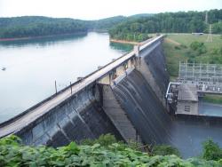
Norris Dam impounds the Clinch River, a mountain tributary of the Tennessee River. The facility stands as a tribute and symbol of the birth of the Tennessee Valley Authority (TVA). Given broad jurisdiction over resource development in the watershed (a 40,000-square-mile basin comprising parts of Virginia, North Carolina, Georgia, Alabama, Mississippi, Kentucky, and Tennessee), the TVA was formed to plan for flood control, improve navigation, and produce hydroelectric power.
YearAdded:
Image Credit:
Courtesy Flickr/vosburg09 (CC BY 2.0)
Image Caption:
Norris Dam
Era_date_from:
1936
1986
Innovations

Norris Dam impounds the Clinch River, a mountain tributary of the Tennessee River. The facility stands as a tribute and symbol of the birth of the Tennessee Valley Authority (TVA). Given broad jurisdiction over resource development in the watershed (a 40,000-square-mile basin comprising parts of…
Read More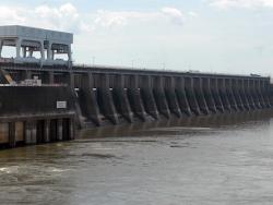
In 1930, the U.S. Corps of Engineers was directed to complete an engineering survey of the Tennessee River to determine the feasibility of establishing complete river navigability. The resulting report recommended a series of nine main river dams and several tributary dams to allow for a minimum…
Read More